| |
|
|
|
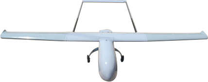
Eagle Eye Mini UAV
Eagle Eye is a fully autonomous Mini Unmanned Fixed Wing aircraft. It is capable of carrying a 400 Gram payload
and is ideally suited for surveying work. The payload is a day still camera.
Most high quality cameras are under 400 Grams. The UAV is powered by a small petrol engine.
The aircraft is autonomous right from Takeoff to Landing.
For ease of operation the aircraft is capable of takeoff from a very small patch and normal ground landing.
The UAV airframe is made of Elasto-Polymer foam and Carbon Fiber Composites.
|
|
| Physical Specifications: |
| |
Wing Span |
: |
3000mm |
| |
Length |
: |
2000mm |
| |
Height |
: |
300mm |
| |
Flying Weight |
: |
3500gms |
| |
Payload |
: |
800 gms |
| |
Propulsion |
: |
15cc 2-stroke Petrol Engine |
| |
Propeller |
: |
11x6 Fiber Reinforced Nylon |
|
| Flying Characteristics: |
| |
Range |
: |
10KM* |
| |
Endurance |
: |
100 Mins + 20 Mins reserve for failsafe |
| |
Accuracy |
: |
Within 10 meters of programmed waypoint |
| |
Cruise Speed |
: |
48 Km/Hr |
| |
Max Speed |
: |
60 Km/Hr |
| |
Stall Speed |
: |
35 Km/Hr |
| |
Max Wind |
: |
20 Km/Hr. |
| |
Altitude |
: |
3000 Meters |
| *Total Distance Traversed: 48Km |
|
|
| Capabilities: |
- Fully Autonomous from Takeoff to Landing.
- Can be programmed for 300 Waypoints/Mission Commands.
- Can ‘Loiter’ over the subject at any waypoint.
- Has Manual over ride at any stage.
- Can be ‘Guided’ to specific location during flight by clicking over map.
- Can activate/deactivate any payload from the GCS.
- Auto payload activation on reaching the waypoint.
- Failsafe built in.Will ‘RTL’ if link is lost. Will ‘Land’ if battery is low.
- GCS switchable navigation lights.
|
|
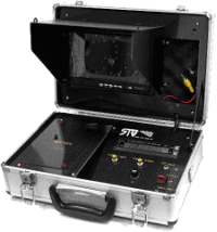
| Standard Package : |
- Eagle Eye Aircraft 1 Nos.
- GCS consisting of windows based palmtop.
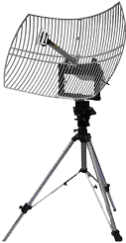
- Yagi Antenna for Data Link.
- Microprocessor based battery Charger.
- Radio Control Transmitter.
- Mini Tool Kit.
- Semi Ruggedized Carry Box.
|
|
| Auto Pilot: |
- Based on ARM Cortex M4 32 bit Processor @168 Mhz, running at 252 MIPS, RTOS.
- MPU-6000 Invensense 3-D Six Axis, Dual Gyro+Acc
- uBlox GPS with positioning from GPSS, GLONSS, Galelio, Biedu
- Secondary GPS for backup (optional)
- HMC5883L 3-Axis Dual Magnetometer
- MS5611 High Resolution Barometer
- Onboard Micro SD card for Flight Data Logging
- RTK GPS (Optional)
|
|
| Data Link: |
| |
Output Power |
: |
500mW |
| |
Modulation Type |
: |
FHSS |
| |
Freq Band |
: |
900 Mhz (885-915 Mhz) |
| |
Range |
: |
10 Km (with Yagi antenna) |
|
| |
|
| |
| Radio Control Link: |
| |
Encoding |
: |
PPM |
| |
Modulation |
: |
FHSS |
| |
Freq Band |
: |
400-455 Mhz |
| |
Max RF Output |
: |
500 mW |
| |
Channels |
: |
8 |
| |
Range |
: |
5 Km when airborne |
| |
Display |
: |
Back-Lit LCD panel on Tx |
| |
Battery |
|
Li-Poly 11.1V, 2650 mAh (10 Hrs continuous operations). |
|
|
|
|
|
|